Print preview Close
Showing 811 results
Archival description
Beaverton, Ontario: fire insurance plan / Charles E. Goad Company
Beaverton, Ontario: fire insurance plan / Charles E. Goad Company
Bowmanville, Ontario: fire insurance plan / Chas. E. Goad Company
Bowmanville, Ontario: fire insurance plan / Chas. E. Goad Company
Bobcaygeon Road : Re-survey fonds. Additions
Bobcaygeon Road : Re-survey fonds. Additions
Bracebridge, Ontario: Fire Insurance Plan / Underwriters' Survey Bureau
Bracebridge, Ontario: Fire Insurance Plan / Underwriters' Survey Bureau
Campbellford, Ontario: fire insurance plan
Campbellford, Ontario: fire insurance plan
Castleton, Ontario: fire insurance plan / Charles E. Goad
Castleton, Ontario: fire insurance plan / Charles E. Goad
Coboconk, Ontario: fire insurance plan / Chas. E. Goad Company
Coboconk, Ontario: fire insurance plan / Chas. E. Goad Company
Colborne, Ontario: fire insurance plan / Underwriters' Survey Bureau
Colborne, Ontario: fire insurance plan / Underwriters' Survey Bureau
Index: United Counties of Northumberland and Durham: Case Records, 1914-1917
Cobourg, Ontario: fire insurance plan / Underwriters' Survey Bureau
Cobourg, Ontario: fire insurance plan / Underwriters' Survey Bureau
Toronto, Ontario: fire insurance plan / Underwriters' Survey Bureau
Toronto, Ontario: fire insurance plan / Underwriters' Survey Bureau
Peterborough, Ontario: fire insurance plan / Chas. E. Goad Company
Peterborough, Ontario: fire insurance plan / Chas. E. Goad Company
Pontypool, Ontario: fire insurance plan / Charles E. Goad
Pontypool, Ontario: fire insurance plan / Charles E. Goad
Queensborough, Ontario: fire insurance plan / Charles E. Goad
Queensborough, Ontario: fire insurance plan / Charles E. Goad
Victoria Road, Ontario: fire insurance plan / Charles E. Goad
Victoria Road, Ontario: fire insurance plan / Charles E. Goad
Trenton, Ontario: fire insurance plan / Underwriters' Survey Bureau
Trenton, Ontario: fire insurance plan / Underwriters' Survey Bureau
T.E.W. Nind recorded interview (1 of 2)
T.E.W. Nind recorded interview (1 of 2)
T.E.W. Nind recorded interview (2 of 2)
T.E.W. Nind recorded interview (2 of 2)
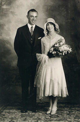
Sydney Helmer Standen and Euphemia Young McQueen on their wedding day, Saskatoon (Photo credit: Gibson Photos, Saskatoon)
![Arctic Regions. 1680? De Wit, Frederick Poli Arctici et circumiacentium terrarum descriptio novissima per Fredericum de Wit Amstelodami. [Amsterdam, 1680?] Coloured. "Gedruckt i Amsteldam by Frederick de Wit in de Valverstract aen den Dam in de Wit paseaert"](/uploads/r/trent-university-archives/4/d/1/4d1c8177182fc5b22deb00d0eea3ae725cb0261e610b5b1ea241232aca447139/poliartici_142.jpg)
Arctic Regions. 1680? De Wit, Frederick Poli Arctici et circumiacentium terrarum descriptio novissima per Fredericum de Wit Amstelodami. [Amsterdam, 1680?] Coloured. "Gedruckt i Amsteldam by Frederick de Wit in de Valverstract aen den Dam in de Wit paseaert"
America. 1747 Bowen, Emanuel, d. 1767 A new general map of America. Outline drawn from several accurate particular maps and charts, regulated by Astronomical Observations by Eman. Bowen. London, 1747. "No. 51" From: A Complete System of Geography, London, 1744-1747. Phillips, Maps. p. 108 no. 70
America. 1747 Bowen, Emanuel, d. 1767 A new general map of America. Outline drawn from several accurate particular maps and charts, regulated by Astronomical Observations by Eman. Bowen. London, 1747. "No. 51" From: A Complete System of Geography, London, 1744-1747. Phillips, Maps. p. 108 no. 70
Arctic Regions. 1595 Mercator, Gerhard, 1512-1594 Sep: Tentrio: Nalium [i.e. Septentrionalium] Terrarum de: Scriptio. Per Gerardum Mercatorem cum privilegio. Includes 3 inset maps: Frisland Insula, Farre Insulae, Scetland Insulae. Originally published 1595. This copy published? First separate map of the North Pole
Arctic Regions. 1595 Mercator, Gerhard, 1512-1594 Sep: Tentrio: Nalium [i.e. Septentrionalium] Terrarum de: Scriptio. Per Gerardum Mercatorem cum privilegio. Includes 3 inset maps: Frisland Insula, Farre Insulae, Scetland Insulae. Originally published 1595. This copy published? First separate map of the North Pole
Arctic Regions. 1680 Blaeu, Willem Janszoon, 1571-1638 Arctic map. Regiones sub Polo Arctico auctore Guiljelmo Blaeu. [Amsterdam, ca. 1680]. Coloured in outline. Dutch text on verso
Arctic Regions. 1680 Blaeu, Willem Janszoon, 1571-1638 Arctic map. Regiones sub Polo Arctico auctore Guiljelmo Blaeu. [Amsterdam, ca. 1680]. Coloured in outline. Dutch text on verso
Canada, Eastern. 1851 Rapkin, J East Canada and New Brunswick. The illustrations by H. Warren and engraved by J.B. Allen. Map drawn and engraved by J. Rapkin. London, J. Tallis, 1851. Coloured in outline. Coloured illustrations surround the map: Quebec, North American Indians. Has the seal of Lower Canada printed on the page. From: Tallis's Illustrated Atlas and Modern History of the World
Canada, Eastern. 1851 Rapkin, J East Canada and New Brunswick. The illustrations by H. Warren and engraved by J.B. Allen. Map drawn and engraved by J. Rapkin. London, J. Tallis, 1851. Coloured in outline. Coloured illustrations surround the map: Quebec, North American Indians. Has the seal of Lower Canada printed on the page. From: Tallis's Illustrated Atlas and Modern History of the World
Hudson Bay. 1757 Bellin, Jacques Nicholas, 1703-1772 Carte de la Baye Hudson pour servira l'Histoire generale des voyages echelle de lieues communes de France par M. B.[ellin] Ingr. de la Marine, 1757. Coloured. 9 x 12 in. In upper left corner "Tome 14 in 4 No. 14"; in top right corner: "tome 14 in 8 Page 191". From: Charlevoix, Pierre Francois Xavier de, 1682-1761. Histoire et description generale de la Nouvelle France. Map no. ? See M. Bellin's introduction on maps in vol. III of Charlevoix
Hudson Bay. 1757 Bellin, Jacques Nicholas, 1703-1772 Carte de la Baye Hudson pour servira l'Histoire generale des voyages echelle de lieues communes de France par M. B.[ellin] Ingr. de la Marine, 1757. Coloured. 9 x 12 in. In upper left corner "Tome 14 in 4 No. 14"; in top right corner: "tome 14 in 8 Page 191". From: Charlevoix, Pierre Francois Xavier de, 1682-1761. Histoire et description generale de la Nouvelle France. Map no. ? See M. Bellin's introduction on maps in vol. III of Charlevoix