90-001/001(01c)024
·
Item
·
[188-?]
Part of David Macmillan fonds
380 results with digital objects
Show results with digital objects
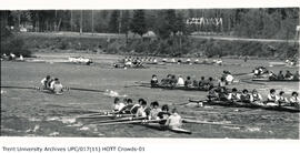
UPC/017(11) HOTT Crowds -01
·
Item
·
[198-?]
Part of University photograph collection
Photograph of multiple 9 person rowing teams sitting in their rowing boats on the Otonabee River during the Head of the Trent Regatta held annually by Trent University. The teams are actively racing down the river in the photo.
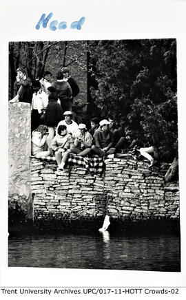
UPC/017(11) HOTT Crowds-02
·
Item
·
[198-?] to [199-?]
Part of University photograph collection
Photograph of a group of students gathered together on the bank of the Otonabee River to watch the Head of the Trent Regatta races. They are located on the West Bank near Champlain College. Some are taking photos and others are gathered around chatting.
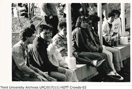
UPC/017(11) HOTT Crowds-03
·
Item
·
[198-?] to [199-?]
Part of University photograph collection
Photograph of multiple students sitting along the Bata Library catwalk as they cheer on the rowers in their races during the annual Head of the Trent Regatta. Students can be seen bundled in sweaters sitting in between the flag poles that line the top of the catwalk.
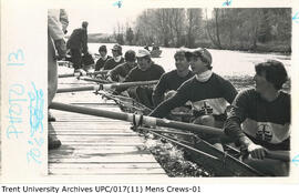
UPC/017(11) Mens Crews-01
·
Item
·
[199-?]
Part of University photograph collection
Photograph of a 7x Trent men's rowing team loaded in their boat along a dock in the Otonabee River. The 7 men are in Trent jerseys looking up at their coach as they get ready to push off the dock. Another boat can be seen sitting behind them as they prepare for the Head of the Trent rowing Regatta.
87-001/HMC03
·
Item
·
1556
Part of Robert Lloyd Hunter collection
87-001/HMC08
·
Item
·
[1556?]
Part of Robert Lloyd Hunter collection
87-001/HMC07
·
Item
·
1565
Part of Robert Lloyd Hunter collection
87-001/HMC09
·
Item
·
[1565?]
Part of Robert Lloyd Hunter collection
87-001/HMC04
·
Item
·
[1565?]
Part of Robert Lloyd Hunter collection
87-001/HMC27
·
Item
·
1595
Part of Robert Lloyd Hunter collection
02-1004
·
Item
·
1620-1621
Item is an original handwritten manuscript of the proceedings of the British Parliament during the reign of James I, dated February 1620 to December 1621. The manuscript is written on rag paper and is 117 pages in length. It is bound in half-calf, and the spine has the inscription: "Phillips MSS 3093." The binder's ticket on the inside cover has the inscription: "Bretherton ligavit 1848."
British Parliament
87-001/MC11(16)
·
Item
·
[1674?]
Part of Robert Lloyd Hunter collection
![Arctic Regions. 1680? De Wit, Frederick Poli Arctici et circumiacentium terrarum descriptio novissima per Fredericum de Wit Amstelodami. [Amsterdam, 1680?] Coloured. "Gedruckt i Amsteldam by Frederick de Wit in de Valverstract aen den Dam in de Wit paseaert"](/uploads/r/trent-university-archives/4/d/1/4d1c8177182fc5b22deb00d0eea3ae725cb0261e610b5b1ea241232aca447139/poliartici_142.jpg)
87-001/HMC28
·
Item
·
1680?
Part of Robert Lloyd Hunter collection
A highly decorative piece consisting of a circular map 17 in. in diameter of the Arctic set within a rectangle 19 x 17 in. with its remaining portions filled with remarkable coloured vignettes of whaling scenes in the northern regions. The Arctic is shown in its standard form for this period ... with Northwest America absent due to lack of available knowledge.
87-001/HMC13
·
Item
·
1680
Part of Robert Lloyd Hunter collection
87-001/HMC18
·
Item
·
1688
Part of Robert Lloyd Hunter collection
87-001/HMC17
·
Item
·
1689
Part of Robert Lloyd Hunter collection
87-001/HMC16
·
Item
·
1695-1697
Part of Robert Lloyd Hunter collection
87-001/MC11(03)
·
Item
·
[1703?]
Part of Robert Lloyd Hunter collection
87-001/MC11(01)
·
Item
·
1705
Part of Robert Lloyd Hunter collection
22-009
·
Item
·
1719
Item is the top part of Chatelain's 1719 map of North America. This is the top part of the map, and does not include the separately published bottom part devoted to South America, Africa, and the South Pacific Ocean.