Print preview Close
Showing 1671 results
Archival description
Collect in the Kawarthas (journal)
Collect in the Kawarthas (journal)
Edith Fowke manuscript
Edith Fowke manuscript
F.W. Hilshaw notebook
F.W. Hilshaw notebook
Account book
Account book
Fun in the water at Second Beach [Three men in water includes Bob Waterfield, Supervisor of Bowmanville Boys' School]
Fun in the water at Second Beach [Three men in water includes Bob Waterfield, Supervisor of Bowmanville Boys' School]
Morning Watch: Looking west into Beaver Bay, Jack Griffith and Bob Gladish
Morning Watch: Looking west into Beaver Bay, Jack Griffith and Bob Gladish
Nature Lessons [Group of campers with Claire Zufeldt]
Nature Lessons [Group of campers with Claire Zufeldt]
Indian Night, John Kennedy and Doug Goudie
Indian Night, John Kennedy and Doug Goudie
Flag-raising ceremony at Morning Watch, Jack Watts, Penny Hayes, Bob McGregor
Flag-raising ceremony at Morning Watch, Jack Watts, Penny Hayes, Bob McGregor
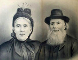
Photograph of Hugh and Annie Caldwell, courtesy of Leonard Caldwell.
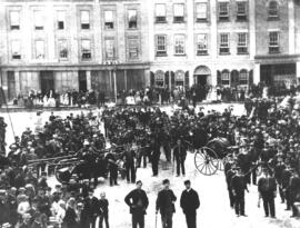
Peterborough Fire Brigade, n.d.
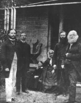
The Moodie Family, n.d.
Journal of the British Parliament from February 1620 to December 1621, reign of James I
Journal of the British Parliament from February 1620 to December 1621, reign of James I
Newfoundland. Kitchin, Thomas, d. 1784. A new map of the only useful and frequented part of New Found Land. London. From: The London Magazine v. 31, p. 408
Newfoundland. Kitchin, Thomas, d. 1784. A new map of the only useful and frequented part of New Found Land. London. From: The London Magazine v. 31, p. 408
Quebec. Kitchin, Thomas, d. 1784. A new map of the Province of Quebec in North America. [London?]
Quebec. Kitchin, Thomas, d. 1784. A new map of the Province of Quebec in North America. [London?]
Canada. 20 Hall, Sidney, fl. 1817-1860. British North America, by Sidney Hall. London, published for Longman, Rees, Orme, Brown & Green, April 1st, 1829. Coloured in outline. 16 x 20 in. Plate no. 45. From Hall's A New General Atlas with the Divisions and Boundaries Carefully Coloured. Phillips Atlases, 756
Canada. 20 Hall, Sidney, fl. 1817-1860. British North America, by Sidney Hall. London, published for Longman, Rees, Orme, Brown & Green, April 1st, 1829. Coloured in outline. 16 x 20 in. Plate no. 45. From Hall's A New General Atlas with the Divisions and Boundaries Carefully Coloured. Phillips Atlases, 756
Canada. 4 Finley, Anthony Canada. Philadelphia, A. Finley, 1833. Phillips Atlases, 3551, Map no. 5
Canada. 4 Finley, Anthony Canada. Philadelphia, A. Finley, 1833. Phillips Atlases, 3551, Map no. 5
Canada. 23 Arrowsmith, John, 1790-1873 British North America, by permission dedicated to Hon. Hudsons Bay Company, containing the latest information which their documents furnish. London, J. Arrowsmith, pub. 25 April, 1850. "Map no. 40" Phillips Maps p. 198. Phillips Atlases, 789
Canada. 23 Arrowsmith, John, 1790-1873 British North America, by permission dedicated to Hon. Hudsons Bay Company, containing the latest information which their documents furnish. London, J. Arrowsmith, pub. 25 April, 1850. "Map no. 40" Phillips Maps p. 198. Phillips Atlases, 789
Canada. 7 Canada. Published by Orr & Co., Amen Corner, Paternoster Row, London
Canada. 7 Canada. Published by Orr & Co., Amen Corner, Paternoster Row, London
Chedabucto Bay (N.S.). 12 Bellin, Jacques Nicolas Plan de la Bave Chedabouct, aujourd'hui Havre de Milfort, par M. B[ellin]. Paris, 1744. From: Charlevoix, Pierre Francois Xavier de, 1682-1761. Histoire et description generale de la Nouvelle France. Map no. 6. See M. Bellin's introduction on maps in vol. III of Charlevoix
Chedabucto Bay (N.S.). 12 Bellin, Jacques Nicolas Plan de la Bave Chedabouct, aujourd'hui Havre de Milfort, par M. B[ellin]. Paris, 1744. From: Charlevoix, Pierre Francois Xavier de, 1682-1761. Histoire et description generale de la Nouvelle France. Map no. 6. See M. Bellin's introduction on maps in vol. III of Charlevoix
North America. 24 Sanson, Nicolas, 1600-1667 Amerique Septentrionale divisee en ses principales parties ou sont distingues les vns des autres les estats suivant quils appartiennent presentemet aux Francois, Castillans, Anglois, Suedois, Danois, Hollandois, tiree des relations de toutes ces nations par le S. Sanson, geographe ordinaire du Roy. A Paris, chez H. Jaillot, joignant les grands Augustins aux deux globes, 1674. Coloured in outline. Large title cartouche and cartouche of scales both uncoloured. Copy of the first edition only a few copies of which are recorded. California is copied from Sanson's 1656 map. The remainder of the map is based on Sanson's 1669 Map. Omits Montreal. [Jaillot, Alexis Hubert, 1632?-1712]
North America. 24 Sanson, Nicolas, 1600-1667 Amerique Septentrionale divisee en ses principales parties ou sont distingues les vns des autres les estats suivant quils appartiennent presentemet aux Francois, Castillans, Anglois, Suedois, Danois, Hollandois, tiree des relations de toutes ces nations par le S. Sanson, geographe ordinaire du Roy. A Paris, chez H. Jaillot, joignant les grands Augustins aux deux globes, 1674. Coloured in outline. Large title cartouche and cartouche of scales both uncoloured. Copy of the first edition only a few copies of which are recorded. California is copied from Sanson's 1656 map. The remainder of the map is based on Sanson's 1669 Map. Omits Montreal. [Jaillot, Alexis Hubert, 1632?-1712]
North America. 2 Finley, Anthony North America. Philadelphia, A. Finley. Phillips Atlases, 3551 Map no. 4
North America. 2 Finley, Anthony North America. Philadelphia, A. Finley. Phillips Atlases, 3551 Map no. 4
Peter Russell correspondence copy book
Peter Russell correspondence copy book
Map: Lake Superior by Lieut. Henry Wr. Bayfield assisted by Mr. Philip Ed Collins Mid. Between the Years 1823 & 1825. Quebec, Crown Lands Department, 12th March 1853. Certified a true copy
Map: Lake Superior by Lieut. Henry Wr. Bayfield assisted by Mr. Philip Ed Collins Mid. Between the Years 1823 & 1825. Quebec, Crown Lands Department, 12th March 1853. Certified a true copy
Collective Agreement between the Board of Governors of Trent University and the Trent University Faculty Association (TUFA) of Trent University
Collective Agreement between the Board of Governors of Trent University and the Trent University Faculty Association (TUFA) of Trent University