Showing 811 results
Archival description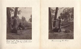
Sample Image
Conditions of Sale
Conditions of Sale
Deed for taxes to Thos. Fairbairn
Deed for taxes to Thos. Fairbairn
Deed George Barlee to Rev. V. Clementi
Deed George Barlee to Rev. V. Clementi
Stautory Declarations J.D. Collins, J.A. Hall and E.H.D Hall
Stautory Declarations J.D. Collins, J.A. Hall and E.H.D Hall
Cobourg, Ontario: fire insurance plan / Underwriters' Survey Bureau
Cobourg, Ontario: fire insurance plan / Underwriters' Survey Bureau
Selected images, courtesy of Anthony Hopkins. 2
Isabella Carr letter
Isabella Carr letter
America. 1747 Bowen, Emanuel, d. 1767 A new general map of America. Outline drawn from several accurate particular maps and charts, regulated by Astronomical Observations by Eman. Bowen. London, 1747. "No. 51" From: A Complete System of Geography, London, 1744-1747. Phillips, Maps. p. 108 no. 70
America. 1747 Bowen, Emanuel, d. 1767 A new general map of America. Outline drawn from several accurate particular maps and charts, regulated by Astronomical Observations by Eman. Bowen. London, 1747. "No. 51" From: A Complete System of Geography, London, 1744-1747. Phillips, Maps. p. 108 no. 70
Arctic Regions. 1595 Mercator, Gerhard, 1512-1594 Sep: Tentrio: Nalium [i.e. Septentrionalium] Terrarum de: Scriptio. Per Gerardum Mercatorem cum privilegio. Includes 3 inset maps: Frisland Insula, Farre Insulae, Scetland Insulae. Originally published 1595. This copy published? First separate map of the North Pole
Arctic Regions. 1595 Mercator, Gerhard, 1512-1594 Sep: Tentrio: Nalium [i.e. Septentrionalium] Terrarum de: Scriptio. Per Gerardum Mercatorem cum privilegio. Includes 3 inset maps: Frisland Insula, Farre Insulae, Scetland Insulae. Originally published 1595. This copy published? First separate map of the North Pole
Arctic Regions. 1680 Blaeu, Willem Janszoon, 1571-1638 Arctic map. Regiones sub Polo Arctico auctore Guiljelmo Blaeu. [Amsterdam, ca. 1680]. Coloured in outline. Dutch text on verso
Arctic Regions. 1680 Blaeu, Willem Janszoon, 1571-1638 Arctic map. Regiones sub Polo Arctico auctore Guiljelmo Blaeu. [Amsterdam, ca. 1680]. Coloured in outline. Dutch text on verso
Arctic Regions. 1680 Pitt, Moses, fl. 1654-1696 A map of the North Pole and the parts adjoining. Oxon, At the Theater, MDCLXXX. Has two coloured illustrations: one of a family in Eskimo dress and the other of fishermen harpooning a whale. Inset map at top right is of Nova Zembla [Zembia?] Has note: In the Philosophical Transactions of ao. 1674, no. 101, there is set down a description of Nova Zembla as it was sent to the Royal Society from a Russian merchant and discovered by order of the Grand Czaar, but there being not joyned to it either longitude latitude or other measure, we thought it better to follow the two newest maps. One printed at Amsterdam 1678 the other at Nuremberg 1679 and to place this by itself which shews it not an island but joyned with the continent at the letter K." Map dedicated to the Right Honble. Charles FitzCharles, Earle of Plymouth ... Taken from vol. 1 of Pitt's English Atlas published under Royal patronage in 1680. The Atlas bankrupted Pitt; only
Arctic Regions. 1680 Pitt, Moses, fl. 1654-1696 A map of the North Pole and the parts adjoining. Oxon, At the Theater, MDCLXXX. Has two coloured illustrations: one of a family in Eskimo dress and the other of fishermen harpooning a whale. Inset map at top right is of Nova Zembla [Zembia?] Has note: In the Philosophical Transactions of ao. 1674, no. 101, there is set down a description of Nova Zembla as it was sent to the Royal Society from a Russian merchant and discovered by order of the Grand Czaar, but there being not joyned to it either longitude latitude or other measure, we thought it better to follow the two newest maps. One printed at Amsterdam 1678 the other at Nuremberg 1679 and to place this by itself which shews it not an island but joyned with the continent at the letter K." Map dedicated to the Right Honble. Charles FitzCharles, Earle of Plymouth ... Taken from vol. 1 of Pitt's English Atlas published under Royal patronage in 1680. The Atlas bankrupted Pitt; only
America. Gastaldi, Giacomo, ca. 1500-ca. 1565 Universale della Parte del Mondo nuovamente Ritrovata. [Second ed.? Paris? 1565?] Taken from vol. 3 of Ramusio's Navigationi et Viaggi, Venice, 1565. [Ramusio, Giovanni Battista, 1485-1517]
America. Gastaldi, Giacomo, ca. 1500-ca. 1565 Universale della Parte del Mondo nuovamente Ritrovata. [Second ed.? Paris? 1565?] Taken from vol. 3 of Ramusio's Navigationi et Viaggi, Venice, 1565. [Ramusio, Giovanni Battista, 1485-1517]
Arctic Regions. 1831 Society for the Diffusion of Useful Knowledge (Great Britain) Circumjacent to the North Pole. London, Published by Baldwin and Cradock, 47 Paternoster Row, June, 1831 under the superintendence of the Society for the Diffusion of Useful Knowledge. Phillips Atlases, 753
Arctic Regions. 1831 Society for the Diffusion of Useful Knowledge (Great Britain) Circumjacent to the North Pole. London, Published by Baldwin and Cradock, 47 Paternoster Row, June, 1831 under the superintendence of the Society for the Diffusion of Useful Knowledge. Phillips Atlases, 753
Canada, Eastern. 1689 Coronelli, Vincenzo, 1650-1697. Partie Orientale du Canada ou de la Nouvelle France ou sont les provinces, ou pays de Saguenay, Canada, Acadie, etc. les peuples, ou nations des Etechemins, Iroquois, Attiquameches etc. avec la Nouvelle Angleterre, la Nouvelle Ecosse, la Nouvelle Yorck, et la Virginie, les Isles de Terre Neuve, de Cap Breton etc., le Grand Banc, etc. Dresee sur les memoires le plus nouveaux par le P. Coronelli, Cosmographe et de la Ser. Rep. de Venise. Corrigee et augmentee par le Sr. Tillemon, et dedice a Monsieur l'Abbe Baudrand par son humble serviteur I.B. Nolin. A Paris chez I.B. Nolin sur le Quay de l'Horloge du Palais, proche le Ponte-Neuf a l'Enseigne de la Place des Victories. Avec privilege du Roy, 1689. Coloured. Has two illustrations: Indian armee, and Indien en habit de chasse
Canada, Eastern. 1689 Coronelli, Vincenzo, 1650-1697. Partie Orientale du Canada ou de la Nouvelle France ou sont les provinces, ou pays de Saguenay, Canada, Acadie, etc. les peuples, ou nations des Etechemins, Iroquois, Attiquameches etc. avec la Nouvelle Angleterre, la Nouvelle Ecosse, la Nouvelle Yorck, et la Virginie, les Isles de Terre Neuve, de Cap Breton etc., le Grand Banc, etc. Dresee sur les memoires le plus nouveaux par le P. Coronelli, Cosmographe et de la Ser. Rep. de Venise. Corrigee et augmentee par le Sr. Tillemon, et dedice a Monsieur l'Abbe Baudrand par son humble serviteur I.B. Nolin. A Paris chez I.B. Nolin sur le Quay de l'Horloge du Palais, proche le Ponte-Neuf a l'Enseigne de la Place des Victories. Avec privilege du Roy, 1689. Coloured. Has two illustrations: Indian armee, and Indien en habit de chasse
Unlabelled videotape [blank?]
Unlabelled videotape [blank?]
George Barker Hall indenture
George Barker Hall indenture
Judge John E. Harding letter
Judge John E. Harding letter
Hastings, Ontario Tanners softball team scorecard
Hastings, Ontario Tanners softball team scorecard
Great Lakes. 1787-1788 Bonne, Rigobert, 1727-1794 Partie Occidentale du Canada contenant les cinq Grands Lacs, avec les pays circonvoisins, par M. Bonne, Ingenieur-Hydrographie de la Marin. [Paris? 1787-1788] Coloured in outline. From: Atlas Encyclopedique. "Liv XV, XVI,et XVII" "No. 45" Phillips Maps no. 45
Great Lakes. 1787-1788 Bonne, Rigobert, 1727-1794 Partie Occidentale du Canada contenant les cinq Grands Lacs, avec les pays circonvoisins, par M. Bonne, Ingenieur-Hydrographie de la Marin. [Paris? 1787-1788] Coloured in outline. From: Atlas Encyclopedique. "Liv XV, XVI,et XVII" "No. 45" Phillips Maps no. 45
North America, Eastern. Homann, Johann Baptist, 1663-1724. La Louisiane. Amplissimae Regions Mississippi seu. Provinciae Ludocivianae a R.P. Ludovico Hennepin in America Septentrionali Anno 1687 detectae nunc Gallorum Coloniis et Actionum Megotilis toto Orbe celeberrimae, Nova Tabula edita a Io. Bapt. Homanno. [Nuremberg, 1705?] Coloured map with black and white illustrations of beavers at Niagara Falls and of Indigenous people standing beside a buffalo
North America, Eastern. Homann, Johann Baptist, 1663-1724. La Louisiane. Amplissimae Regions Mississippi seu. Provinciae Ludocivianae a R.P. Ludovico Hennepin in America Septentrionali Anno 1687 detectae nunc Gallorum Coloniis et Actionum Megotilis toto Orbe celeberrimae, Nova Tabula edita a Io. Bapt. Homanno. [Nuremberg, 1705?] Coloured map with black and white illustrations of beavers at Niagara Falls and of Indigenous people standing beside a buffalo
North America, Eastern. Chatelain, Henri Abraham Carte de la Nouvelle France, ou se voit le cours des Grandes Rivieres de S. Laurens & de Mississippi Aujour d'ui. [Paris?] 1719. Includes inset map of the coast of Louisiana. A plan and view of Quebec are engraved in a cartouche in the lower right hand corner. From: t. 6 (1719) of Chatelain's Atlas Historique, 1705-1720, with text by Guedeville. Phillips, Maps, p. 567. [was originally in Slot 26]
North America, Eastern. Chatelain, Henri Abraham Carte de la Nouvelle France, ou se voit le cours des Grandes Rivieres de S. Laurens & de Mississippi Aujour d'ui. [Paris?] 1719. Includes inset map of the coast of Louisiana. A plan and view of Quebec are engraved in a cartouche in the lower right hand corner. From: t. 6 (1719) of Chatelain's Atlas Historique, 1705-1720, with text by Guedeville. Phillips, Maps, p. 567. [was originally in Slot 26]
North America, Eastern. Moll, Herman, d. 1732 A map of New France containing Canada, Louisiana &c. in North America according to the patent granted by the King of France to Monsieur Crozat dated the 14th of Sep. 1712 N.S. and registered in the Parliament of Paris the 24th of the same month by H. Moll, Geographer. [London? ca. 1740]. Phliips Atlases, 3526, Map no. 50. April 1997, note glass on picture frame broken
North America, Eastern. Moll, Herman, d. 1732 A map of New France containing Canada, Louisiana &c. in North America according to the patent granted by the King of France to Monsieur Crozat dated the 14th of Sep. 1712 N.S. and registered in the Parliament of Paris the 24th of the same month by H. Moll, Geographer. [London? ca. 1740]. Phliips Atlases, 3526, Map no. 50. April 1997, note glass on picture frame broken
Ontario. Rapkin, J West Canada. The illustration by H. Warren and engraved by Robt. Wallis. Map drawn and engraved by J. Rapkin. London, J. Tallis, 1851. Coloured in outline. Coloured illustrations surrounding the map: Kingston [Ont.], Native Americans, Falls of Niagara. Has printed on it the seal of the Province of Upper Canada. From: Tallis's Illustrated Atlas and Modern History of the World
Ontario. Rapkin, J West Canada. The illustration by H. Warren and engraved by Robt. Wallis. Map drawn and engraved by J. Rapkin. London, J. Tallis, 1851. Coloured in outline. Coloured illustrations surrounding the map: Kingston [Ont.], Native Americans, Falls of Niagara. Has printed on it the seal of the Province of Upper Canada. From: Tallis's Illustrated Atlas and Modern History of the World
Quebec (Que.). [Oakley, Edward, 18th century] A plan of Quebec: Metropolis of Canada in North America. [London, 1759]. From: The London Magazine, 1759. Originally published: London, by E. Oakley and sold by J. Rocque near Round Court in the Strand, 1759. Phillips Atlases, Maps p. 733
Quebec (Que.). [Oakley, Edward, 18th century] A plan of Quebec: Metropolis of Canada in North America. [London, 1759]. From: The London Magazine, 1759. Originally published: London, by E. Oakley and sold by J. Rocque near Round Court in the Strand, 1759. Phillips Atlases, Maps p. 733