Title and statement of responsibility area
Title proper
General material designation
Parallel title
Other title information
Title statements of responsibility
Title notes
- Source of title proper: Title based on the contents of the fonds
Level of description
Repository
Reference code
Edition area
Edition statement
Edition statement of responsibility
Class of material specific details area
Statement of scale (cartographic)
Statement of projection (cartographic)
Statement of coordinates (cartographic)
Statement of scale (architectural)
Issuing jurisdiction and denomination (philatelic)
Dates of creation area
Date(s)
-
1915-1918 (Creation)
- Creator
- Shier, L.V.
Physical description area
Physical description
1 item
30 maps
Publisher's series area
Title proper of publisher's series
Parallel titles of publisher's series
Other title information of publisher's series
Statement of responsibility relating to publisher's series
Numbering within publisher's series
Note on publisher's series
Archival description area
Name of creator
Biographical history
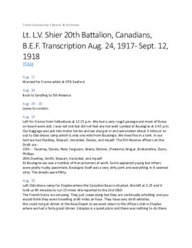
L.V. Shier, son of Dr. Daniel Webster Shier and Helise Alberta Workman, was a lieutenant with the 20th Battalion Canadians, British Expeditionary Forces, during the World War I. . He was discharged from the army September 12, 1918 and later became a doctor. Shier married Blanche Relyea (d.1972).
Custodial history
The collection was in the custody of the Honourable Leslie M. Frost before it was donated to the Trent University Archives.
Scope and content
This fonds consists of World War I trench maps and general maps of the war area. Included are maps of Lens Canal, Passchendaele and general maps of France and Belgium. Also included in the fonds is a bound photocopy of Lieut. L.V. Shier's service diary, 1917-1918.
Notes area
Physical condition
The maps are very fragile and many of them are torn. Handle with care.
Immediate source of acquisition
The fonds was donated by the Honourable Leslie M. Frost. Biographical information was supplied by Laurie Wheeler, half-niece to L.V. Shier.
Arrangement
Language of material
Script of material
Location of originals
Availability of other formats
Restrictions on access
Terms governing use, reproduction, and publication
Finding aids
Associated materials
The Archives of Ontario holds another bound typescipt copy of the diary of L.V. Shier.
For related records see: 77-024.
Accruals
General note
Map Cabinet
Folder 1
This unit consists of nine trench and other maps of locations in Belgium and France from World War 1. The maps are stored in one map folder and are arranged by edition and sheet numbers. Unless noted otherwise, all maps have glossaries and are mounted on cloth.
-
Belgium and part of France: edition 2, sheet 27. Scale 1:40,000 with contour levels and instructions for use. Sheet size: 35' x 25.5"
-
France: sheet 51b. Badly mildewed
-
France: edition 4c, sheet 51C S.E. Scale 1:20,000. "Trenches revised from information received to 28-4-18. Sheet size:34.5 x 25.5. No glossary. Reverse annoted by [L. Shier].
-
France: edition 6, sheet 36b. Scale 1:20,000
-
France: edition 6, sheet 36b S.E. Scale 1:20,000 with contours, references to landmarks, measurement conversion tables. Signed Capt. F.B. Winter
-
France: edition 8a, sheet 36c S.W. Scale 1:20,000. "Trenches corrected to 14-9-16"
-
France: edition 9a, sheet 36c S.W. Scale 1:20,000. "Trenches corrected to 10-2-17" Note on reverse: "Before Vimy attack"
-
Lens: edition 10a, sheet 36c, S.W. Scale 1:10,000. "Trenches corrected to 21-10-17" Artillery locations including guns, howitzer targets and trench mortars. Note on reverse "Barrage Map"
-
France: edition 10d (local) sheet 51B N.W. Scale 1:20,000. "Trenches revised from information received to 30-5-18.
Folder 2
Consisting of 14 trench maps, mounted on paper and in black and white unless otherwise noted. Most are listed by date of correction.
-
Trench Map, 4th C.I.B. No date or scale. Two sheets, each size 7 ¼" x 9 3/8". Includes Cite St. Theodore and Cite des Bureaux.
-
Bois Rase. Scale 1:10,000. Trenches corrected to 20-7-17. Sheet size 13" x 16". Note on reverse: "Hill 70", also a blank message form.
-
Cite St. Elizabeth. Scale 1:10,000. Trenches corrected to 20-8-17. Sheet size 16" x 13".
-
Melville Road. Scale 1:10,000. Trenches corrected to 25-8- 17. Sheet size 19 ¾" x 22 ½". Cloth. Note on reverse: "Lens" and signed by H.G. Ware.
-
Lens Canal. Edition 2. Scale 1:20,000. Trenches corrected to 3-9-17. Sheet size 34 ¾" x 22 3/8".
-
Oostnieuwkerke. Edition 1A, part of Sheet 20. Scale 1:20,000. German trenches corrected to 4-10-17. Sheet size 25" x 19 ¾". Signed on reverse by Lt. Spies.
-
Passchendaele Station. Edition 1A, parts of sheets 20 and 28. Scale 1:10,000. German trenches corrected to 10-10-17. Sheet size 22 ½" x 17 ½". Corner detached. Signatures on reverse: L.V.Shier and Lt. Spies.
-
Waterdamhoek. Edition 1B, part of sheet 28. Scale 1:20,000. German trenches corrected to 10-10-17. Sheet size 23 ¼" x 19 ½". Note on reverse: "Passchendaele" and signed by Lt. Spies.
-
Message Map No. 27. Scale 1:10,000. German trenches corrected to 24-10-17. Sheet size 11" x 12 ¼". Includes Passchendaele. Blank message form on reverse.
-
Lens. No. 2 ("N" Squares). Scale 1:7,500. 1st Nov. 1917. Sheet size 15 ¼" x 20 ½". Aerial photo with corresponding map.
-
Lens Canal. Edition 3. Scale 1:20,000. Trenches corrected to 15-11-17. Sheet size 34 ¾" x 22 ½".
-
Green Crassier. Scale 1:10,000. Trenches corrected to 24-1- 18. Sheet size 16" x 13".
-
Lens Canal. Fifth Edition. Scale 1:20,000. Trenches corrected to 29-1-18. Sheet size 34 ½" x 22 ½".
-
La Souchez River. Cdn. Corps Log Map No. 2. Scale 1:100,000. Trenches and information corrected to 5-2-18. Sheet size 34 ¾" x 22 ¼". Cloth.
Folder 3
Consisting of 7 maps, mounted on paper and in colour unless otherwise noted.
-
Hazenbrouk (Belgium). Edition 2, Sheet 5A. Scale 1:100,000. Dec. 1916. Sheet size 33 7/8" x 27 7/8".
-
Lens (France). Edition 2, Sheet 11. Scale 1:100,000. 1916. Sheet size 33 ½" x 25 ½". Cloth.
-
Valenciennes (Belgium). Edition 2, Sheet 12. Scale 1:100,000. April 1916. Sheet size 33 7/8" x 26 ¾". Note on reverse: "Canal du Nord & Cambrai."
-
Amiens. Edition 2, Sheet 17. Scale 1:100,00. October 1916. Sheet size 33 ¾" x 27 ¾". Note on reverse: "W.A.W. Shier".
-
Namur (Belgium). Sheet 8. Scale 1:100,000. Dec. 1910. Sheet size 33 7/8" x 27 7/8". For official use only. Cloth.
-
St. Quentin (France). Map 18. Scale 1:100,000. Nov. 1915. Sheet size 33 ¾" x 27 ¾".
-
Soissons (France). Sheet 22. Scale 1:100,000. Jan. 1917. Sheet size 33 7/8" x 27 5/8".
Box 1
Bound photocopy of "Active Service Diary from August 24th, 1917"