Showing 811 results
Archival description
Canada, Eastern. 1851 Rapkin, J East Canada and New Brunswick. The illustrations by H. Warren and engraved by J.B. Allen. Map drawn and engraved by J. Rapkin. London, J. Tallis, 1851. Coloured in outline. Coloured illustrations surround the map: Quebec, North American Indians. Has the seal of Lower Canada printed on the page. From: Tallis's Illustrated Atlas and Modern History of the World
Canada, Eastern. 1851 Rapkin, J East Canada and New Brunswick. The illustrations by H. Warren and engraved by J.B. Allen. Map drawn and engraved by J. Rapkin. London, J. Tallis, 1851. Coloured in outline. Coloured illustrations surround the map: Quebec, North American Indians. Has the seal of Lower Canada printed on the page. From: Tallis's Illustrated Atlas and Modern History of the World
Hudson Bay. 1757 Bellin, Jacques Nicholas, 1703-1772 Carte de la Baye Hudson pour servira l'Histoire generale des voyages echelle de lieues communes de France par M. B.[ellin] Ingr. de la Marine, 1757. Coloured. 9 x 12 in. In upper left corner "Tome 14 in 4 No. 14"; in top right corner: "tome 14 in 8 Page 191". From: Charlevoix, Pierre Francois Xavier de, 1682-1761. Histoire et description generale de la Nouvelle France. Map no. ? See M. Bellin's introduction on maps in vol. III of Charlevoix
Hudson Bay. 1757 Bellin, Jacques Nicholas, 1703-1772 Carte de la Baye Hudson pour servira l'Histoire generale des voyages echelle de lieues communes de France par M. B.[ellin] Ingr. de la Marine, 1757. Coloured. 9 x 12 in. In upper left corner "Tome 14 in 4 No. 14"; in top right corner: "tome 14 in 8 Page 191". From: Charlevoix, Pierre Francois Xavier de, 1682-1761. Histoire et description generale de la Nouvelle France. Map no. ? See M. Bellin's introduction on maps in vol. III of Charlevoix
Louisbourg (N.S.). 1758 A map of the harbour of Louisburg and parts adjacent. [London, 1758]. Coloured in outline. 4.5 x 7 in. From: The London Magazine. Phillips Atlases, Maps p. 365
Louisbourg (N.S.). 1758 A map of the harbour of Louisburg and parts adjacent. [London, 1758]. Coloured in outline. 4.5 x 7 in. From: The London Magazine. Phillips Atlases, Maps p. 365
Maritimes. 1716 Moll, Herman, d. 1732 Newfoundland, St. Laurence Bay, the Fishing Banks, Acadia, and a part of New Scotland. By H. Moll, Geographer. London, J. Nicholson, 1716. Coloured in outline. Phillips Maps no. 47
Maritimes. 1716 Moll, Herman, d. 1732 Newfoundland, St. Laurence Bay, the Fishing Banks, Acadia, and a part of New Scotland. By H. Moll, Geographer. London, J. Nicholson, 1716. Coloured in outline. Phillips Maps no. 47
Canada, Eastern. 1625 Purchas, Samuel, 1577?-1626 [Map of Eastern Canada showing New France, New Found Lande, New Scot Lande and New Englande]. [London? 1625?] Coloured in outline. Written in the top left corner of the map: "1872"; in top right corner "1873"
Canada, Eastern. 1625 Purchas, Samuel, 1577?-1626 [Map of Eastern Canada showing New France, New Found Lande, New Scot Lande and New Englande]. [London? 1625?] Coloured in outline. Written in the top left corner of the map: "1872"; in top right corner "1873"
Louisbourg (N.S.). 1758 Jefferys, Thomas, d. 1771 [Two maps of Louisbourg: the first:] A Plan of the city and fortifications of Louisburg from a survey made by Richard Gridley, Lieut. Coll. of the Train of Artillery in 1745. "This important Frenc fortress was taken on the 17th of June 1745 after a siege of 49 days by nine Regiments (that were raised & equiped in 50 days in New England) and commanded by Sr. Willm. Pepperill, assisted by a Fleet under the command of Commodore Warren, with the loss of 101 men killed and 30 that died by sickness. This place was afterwards restored to the French by the Treaty of Aix la Chapel." by Thomas Jefferys, Geographer to the Prince of Wales at Charing Cross, Oct. 9, 1758. [The second:] A plan of the city and harbour of Louisburg, with the French batteries that defended it and those of the English, shewing that part of Gabarus Bay in which they landed, and the ground on which they encamped during the Siege in 1758. This second map has an inset map: A map of Gabarus Bay adjoi
Louisbourg (N.S.). 1758 Jefferys, Thomas, d. 1771 [Two maps of Louisbourg: the first:] A Plan of the city and fortifications of Louisburg from a survey made by Richard Gridley, Lieut. Coll. of the Train of Artillery in 1745. "This important Frenc fortress was taken on the 17th of June 1745 after a siege of 49 days by nine Regiments (that were raised & equiped in 50 days in New England) and commanded by Sr. Willm. Pepperill, assisted by a Fleet under the command of Commodore Warren, with the loss of 101 men killed and 30 that died by sickness. This place was afterwards restored to the French by the Treaty of Aix la Chapel." by Thomas Jefferys, Geographer to the Prince of Wales at Charing Cross, Oct. 9, 1758. [The second:] A plan of the city and harbour of Louisburg, with the French batteries that defended it and those of the English, shewing that part of Gabarus Bay in which they landed, and the ground on which they encamped during the Siege in 1758. This second map has an inset map: A map of Gabarus Bay adjoi
Mackinac, Straits of (Mich.). 1761 A plan of the Straits of St. Mary and Michilimakinac to shew the situation & importance of the two westernmost settlements of Canada for the fur trade. London, 1761. Coloured. The earliest separate map of the Sault Ste. Marie area. From: Gentlemen's Magazine, 1761
Mackinac, Straits of (Mich.). 1761 A plan of the Straits of St. Mary and Michilimakinac to shew the situation & importance of the two westernmost settlements of Canada for the fur trade. London, 1761. Coloured. The earliest separate map of the Sault Ste. Marie area. From: Gentlemen's Magazine, 1761
Maritimes. 1747 Bowen, Emanuel, d. 1767 A new and accurate map of the islands of Newfoundland, Cap Breton, St. John, and Anticosta, together with the neighbouring countries of Nova Scotia, Canada, etc. drawn from the most approved modern maps and charts and regulated by Astronl. Observatns. by Eman. Bowen. London, 1747. Coloured in outline. 13.5 x 16.75 in. "No. 95" Phillips, Maps. p. 475. Slot 39.
Maritimes. 1747 Bowen, Emanuel, d. 1767 A new and accurate map of the islands of Newfoundland, Cap Breton, St. John, and Anticosta, together with the neighbouring countries of Nova Scotia, Canada, etc. drawn from the most approved modern maps and charts and regulated by Astronl. Observatns. by Eman. Bowen. London, 1747. Coloured in outline. 13.5 x 16.75 in. "No. 95" Phillips, Maps. p. 475. Slot 39.
Canada, Eastern. 1689 Coronelli, Vincenzo, 1650-1697. Partie Orientale du Canada ou de la Nouvelle France ou sont les provinces, ou pays de Saguenay, Canada, Acadie, etc. les peuples, ou nations des Etechemins, Iroquois, Attiquameches etc. avec la Nouvelle Angleterre, la Nouvelle Ecosse, la Nouvelle Yorck, et la Virginie, les Isles de Terre Neuve, de Cap Breton etc., le Grand Banc, etc. Dresee sur les memoires le plus nouveaux par le P. Coronelli, Cosmographe et de la Ser. Rep. de Venise. Corrigee et augmentee par le Sr. Tillemon, et dedice a Monsieur l'Abbe Baudrand par son humble serviteur I.B. Nolin. A Paris chez I.B. Nolin sur le Quay de l'Horloge du Palais, proche le Ponte-Neuf a l'Enseigne de la Place des Victories. Avec privilege du Roy, 1689. Coloured. Has two illustrations: Indian armee, and Indien en habit de chasse
Canada, Eastern. 1689 Coronelli, Vincenzo, 1650-1697. Partie Orientale du Canada ou de la Nouvelle France ou sont les provinces, ou pays de Saguenay, Canada, Acadie, etc. les peuples, ou nations des Etechemins, Iroquois, Attiquameches etc. avec la Nouvelle Angleterre, la Nouvelle Ecosse, la Nouvelle Yorck, et la Virginie, les Isles de Terre Neuve, de Cap Breton etc., le Grand Banc, etc. Dresee sur les memoires le plus nouveaux par le P. Coronelli, Cosmographe et de la Ser. Rep. de Venise. Corrigee et augmentee par le Sr. Tillemon, et dedice a Monsieur l'Abbe Baudrand par son humble serviteur I.B. Nolin. A Paris chez I.B. Nolin sur le Quay de l'Horloge du Palais, proche le Ponte-Neuf a l'Enseigne de la Place des Victories. Avec privilege du Roy, 1689. Coloured. Has two illustrations: Indian armee, and Indien en habit de chasse
Great Lakes. 1787-1788 Bonne, Rigobert, 1727-1794 Partie Occidentale du Canada contenant les cinq Grands Lacs, avec les pays circonvoisins, par M. Bonne, Ingenieur-Hydrographie de la Marin. [Paris? 1787-1788] Coloured in outline. From: Atlas Encyclopedique. "Liv XV, XVI,et XVII" "No. 45" Phillips Maps no. 45
Great Lakes. 1787-1788 Bonne, Rigobert, 1727-1794 Partie Occidentale du Canada contenant les cinq Grands Lacs, avec les pays circonvoisins, par M. Bonne, Ingenieur-Hydrographie de la Marin. [Paris? 1787-1788] Coloured in outline. From: Atlas Encyclopedique. "Liv XV, XVI,et XVII" "No. 45" Phillips Maps no. 45
Canada, Eastern. 1556? Gastaldi, Giacomo, ca. 1500-ca. 1565 La Nuova Francia. [Venice? 1556?]. Coloured. 10.6 x 15 in. Map engraved on wood. Drawn by Gastaldi from material supplied by H. Franscatore. Coloured illustrations surrounding the map of Indians carrying on various activities. In top left corner: "424"; top right corner "425". Taken from vol. 3 of Ramusio's Navigation et Viaggi, Venice, 1556?. [Ramusio, Giovanni Battista, 1485-1517]
Canada, Eastern. 1556? Gastaldi, Giacomo, ca. 1500-ca. 1565 La Nuova Francia. [Venice? 1556?]. Coloured. 10.6 x 15 in. Map engraved on wood. Drawn by Gastaldi from material supplied by H. Franscatore. Coloured illustrations surrounding the map of Indians carrying on various activities. In top left corner: "424"; top right corner "425". Taken from vol. 3 of Ramusio's Navigation et Viaggi, Venice, 1556?. [Ramusio, Giovanni Battista, 1485-1517]
Canada, Eastern. 1565? Gastaldi, Giacomo, ca. 1500-ca. 1565 La Nuova Francia. [2. ed. Venice? 1565?] Black and white. 10.6 x 15 in. Map engraved on wood. Drawn by Gastaldi from material supplied by H. Franscatore. Illustrations surrounding the map of Indians carrying on various activities. In top left corner: "424"; top right corner "425". Taken from vol. 3 of Ramusio's Navigation et Viaggi, Venice, 1565?. [Ramusio, Giovanni Battista, 1485-1517]
Canada, Eastern. 1565? Gastaldi, Giacomo, ca. 1500-ca. 1565 La Nuova Francia. [2. ed. Venice? 1565?] Black and white. 10.6 x 15 in. Map engraved on wood. Drawn by Gastaldi from material supplied by H. Franscatore. Illustrations surrounding the map of Indians carrying on various activities. In top left corner: "424"; top right corner "425". Taken from vol. 3 of Ramusio's Navigation et Viaggi, Venice, 1565?. [Ramusio, Giovanni Battista, 1485-1517]
Canada, Eastern. 1695-1697 Coronelli, Vincenzo, 1650-1718 Canada Orientale nell' America Settentrionale de seritta dal P. Mr. Coronelli M.C., Cosmografo della Seren Republica di Venetia. Dedicata alli Mt. Revendi, Patri Li P.P. Minori Conuentuali de Monastero insigne di S. Francesco di Bolognie. [Venice?, published between 1695 and 1697] Coloured. 12 x 18 in. Includes notes relating to fishing off the Grand Banks
Canada, Eastern. 1695-1697 Coronelli, Vincenzo, 1650-1718 Canada Orientale nell' America Settentrionale de seritta dal P. Mr. Coronelli M.C., Cosmografo della Seren Republica di Venetia. Dedicata alli Mt. Revendi, Patri Li P.P. Minori Conuentuali de Monastero insigne di S. Francesco di Bolognie. [Venice?, published between 1695 and 1697] Coloured. 12 x 18 in. Includes notes relating to fishing off the Grand Banks
![Arctic Regions. 1680? De Wit, Frederick Poli Arctici et circumiacentium terrarum descriptio novissima per Fredericum de Wit Amstelodami. [Amsterdam, 1680?] Coloured. "Gedruckt i Amsteldam by Frederick de Wit in de Valverstract aen den Dam in de Wit paseaert"](/uploads/r/trent-university-archives/4/d/1/4d1c8177182fc5b22deb00d0eea3ae725cb0261e610b5b1ea241232aca447139/poliartici_142.jpg)
Arctic Regions. 1680? De Wit, Frederick Poli Arctici et circumiacentium terrarum descriptio novissima per Fredericum de Wit Amstelodami. [Amsterdam, 1680?] Coloured. "Gedruckt i Amsteldam by Frederick de Wit in de Valverstract aen den Dam in de Wit paseaert"
America. 1747 Bowen, Emanuel, d. 1767 A new general map of America. Outline drawn from several accurate particular maps and charts, regulated by Astronomical Observations by Eman. Bowen. London, 1747. "No. 51" From: A Complete System of Geography, London, 1744-1747. Phillips, Maps. p. 108 no. 70
America. 1747 Bowen, Emanuel, d. 1767 A new general map of America. Outline drawn from several accurate particular maps and charts, regulated by Astronomical Observations by Eman. Bowen. London, 1747. "No. 51" From: A Complete System of Geography, London, 1744-1747. Phillips, Maps. p. 108 no. 70
Arctic Regions. 1595 Mercator, Gerhard, 1512-1594 Sep: Tentrio: Nalium [i.e. Septentrionalium] Terrarum de: Scriptio. Per Gerardum Mercatorem cum privilegio. Includes 3 inset maps: Frisland Insula, Farre Insulae, Scetland Insulae. Originally published 1595. This copy published? First separate map of the North Pole
Arctic Regions. 1595 Mercator, Gerhard, 1512-1594 Sep: Tentrio: Nalium [i.e. Septentrionalium] Terrarum de: Scriptio. Per Gerardum Mercatorem cum privilegio. Includes 3 inset maps: Frisland Insula, Farre Insulae, Scetland Insulae. Originally published 1595. This copy published? First separate map of the North Pole
Arctic Regions. 1680 Blaeu, Willem Janszoon, 1571-1638 Arctic map. Regiones sub Polo Arctico auctore Guiljelmo Blaeu. [Amsterdam, ca. 1680]. Coloured in outline. Dutch text on verso
Arctic Regions. 1680 Blaeu, Willem Janszoon, 1571-1638 Arctic map. Regiones sub Polo Arctico auctore Guiljelmo Blaeu. [Amsterdam, ca. 1680]. Coloured in outline. Dutch text on verso
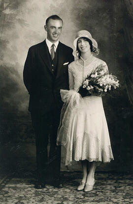
Sydney Helmer Standen and Euphemia Young McQueen on their wedding day, Saskatoon (Photo credit: Gibson Photos, Saskatoon)
T.E.W. Nind recorded interview (2 of 2)
T.E.W. Nind recorded interview (2 of 2)
T.E.W. Nind recorded interview (1 of 2)
T.E.W. Nind recorded interview (1 of 2)
Trenton, Ontario: fire insurance plan / Underwriters' Survey Bureau
Trenton, Ontario: fire insurance plan / Underwriters' Survey Bureau
Victoria Road, Ontario: fire insurance plan / Charles E. Goad
Victoria Road, Ontario: fire insurance plan / Charles E. Goad
Queensborough, Ontario: fire insurance plan / Charles E. Goad
Queensborough, Ontario: fire insurance plan / Charles E. Goad
Pontypool, Ontario: fire insurance plan / Charles E. Goad
Pontypool, Ontario: fire insurance plan / Charles E. Goad
Peterborough, Ontario: fire insurance plan / Chas. E. Goad Company
Peterborough, Ontario: fire insurance plan / Chas. E. Goad Company