Showing 811 results
Archival description
Nova Scotia. 27 A map of the South Part of Nova Scotia and its Fishing Banks with two inserts: A Plan of Halifax Survey'd by M(oses) Harris, and, A View of Halifax drawn from ye top mast head. From: The English Pilot, the fourth book, describing the West-India Navigation, from Hudson's Bay to the river Amazones... Map no. 14. Dublin, 1767. Map also has cartouche: To the right Honble the Lords Comission for Trade and plantations. No author given. Phillips notes the map was probably inserted. Appears to be based on Thomas Jefferys' map of 1750
Nova Scotia. 27 A map of the South Part of Nova Scotia and its Fishing Banks with two inserts: A Plan of Halifax Survey'd by M(oses) Harris, and, A View of Halifax drawn from ye top mast head. From: The English Pilot, the fourth book, describing the West-India Navigation, from Hudson's Bay to the river Amazones... Map no. 14. Dublin, 1767. Map also has cartouche: To the right Honble the Lords Comission for Trade and plantations. No author given. Phillips notes the map was probably inserted. Appears to be based on Thomas Jefferys' map of 1750
Ontario. 9(a) and 9(b) Chewitt, William A map of the located districts in the Province of Upper Canada, describing all the new settlements, townships, &c. with the adjacent frontiers, copied and corrected ... compiled from the survey of William Chewitt senior surveyor & draughtsman ... London, William Faden, January 1st, 1813. Phillips, Maps, p. 194
Ontario. 9(a) and 9(b) Chewitt, William A map of the located districts in the Province of Upper Canada, describing all the new settlements, townships, &c. with the adjacent frontiers, copied and corrected ... compiled from the survey of William Chewitt senior surveyor & draughtsman ... London, William Faden, January 1st, 1813. Phillips, Maps, p. 194
Orleans, Isle d' (Que). 14 Bellin, Jacques Nicolas, 1703-1772. Carte de l'Isle d'Orleans et du passage de la traverse dans le fleuve St. Laurent ... par M. Bellin. Paris, 1744. From: Charlevoix, Pierre Francois Xavier de, 1682-1761. Histoire et description generale de la Nouvelle France. Map no. 12. See M. Bellin's introduction on maps in vol. III of Charlevoix
Orleans, Isle d' (Que). 14 Bellin, Jacques Nicolas, 1703-1772. Carte de l'Isle d'Orleans et du passage de la traverse dans le fleuve St. Laurent ... par M. Bellin. Paris, 1744. From: Charlevoix, Pierre Francois Xavier de, 1682-1761. Histoire et description generale de la Nouvelle France. Map no. 12. See M. Bellin's introduction on maps in vol. III of Charlevoix
Placentia Bay (Nfld.). 13 Bellin, Jacques Nicolas, 1703-1772. Carte des bayes rades et Port de Plaisance dan l'Isle de Terre Neuve ... par M. B[ellin]. Paris, 1744. From: Charlevoix, Pierre Francois Xavier de, 1682-1761. Histoire et description generale de la Nouvelle France. Map no. 2. See M. Bellin's introduction on maps in vol. III of Charlevoix
Placentia Bay (Nfld.). 13 Bellin, Jacques Nicolas, 1703-1772. Carte des bayes rades et Port de Plaisance dan l'Isle de Terre Neuve ... par M. B[ellin]. Paris, 1744. From: Charlevoix, Pierre Francois Xavier de, 1682-1761. Histoire et description generale de la Nouvelle France. Map no. 2. See M. Bellin's introduction on maps in vol. III of Charlevoix
Prince Edward Island. 26 Holland, Samuel, 1728-1801. A map of the Island of St. John, in the Gulf of St. Lawrence divided into counties and parishes and the lots as granted by Government to which are added the soundings round the coast & harbours improved from the late survey of Captain Holland. [London, Sayer & Bennett, 6 April, 1775] From: The North American Pilot for Newfoundland, Labradore, the Gulf and River St. Laurence. Chart XIII
Prince Edward Island. 26 Holland, Samuel, 1728-1801. A map of the Island of St. John, in the Gulf of St. Lawrence divided into counties and parishes and the lots as granted by Government to which are added the soundings round the coast & harbours improved from the late survey of Captain Holland. [London, Sayer & Bennett, 6 April, 1775] From: The North American Pilot for Newfoundland, Labradore, the Gulf and River St. Laurence. Chart XIII
Quebec. 21 Holland, Samuel, 1728-1801. A new map of the Province of Lower Canada, describing all the seigneuries, townships, grants of land, etc. to which is added a plan of the rivers Scoudiac and Magaguadavic, surveyed in 1796, 1797 & 1798 by order of the Commissioners appointed to ascertain the true River St. Croix intended by the Treaty of Peace between His Britannic Majesty and the United States of America. London, William Faden, April 12, 1813. Not in Phillips. This is another issue, without any changes except the date imprint of a map first published August 12, 1802
Quebec. 21 Holland, Samuel, 1728-1801. A new map of the Province of Lower Canada, describing all the seigneuries, townships, grants of land, etc. to which is added a plan of the rivers Scoudiac and Magaguadavic, surveyed in 1796, 1797 & 1798 by order of the Commissioners appointed to ascertain the true River St. Croix intended by the Treaty of Peace between His Britannic Majesty and the United States of America. London, William Faden, April 12, 1813. Not in Phillips. This is another issue, without any changes except the date imprint of a map first published August 12, 1802
Quebec (Que.) 11 Bellin, Jacques Nicolas, 1703-1772. Plan du bassin de Quebec et de ses environs, par M. B[ellin]. Paris, 1744. From: Charlevoix, Pierre Francois Xavier de, 1682-1761. Histoire et description generale de la Nouvelle France. Map no. ? See M. Bellin's introduction on maps in vol. III of Charlevoix
Quebec (Que.) 11 Bellin, Jacques Nicolas, 1703-1772. Plan du bassin de Quebec et de ses environs, par M. B[ellin]. Paris, 1744. From: Charlevoix, Pierre Francois Xavier de, 1682-1761. Histoire et description generale de la Nouvelle France. Map no. ? See M. Bellin's introduction on maps in vol. III of Charlevoix
St. Lawrence, Gulf of. 15 Bellin, Jacques Nicolas, 1703-1772. Carte de Golphe de St. Laurent et pays voisins. Pour servir a l'Histoire generale des voyages. Paris, 1757. From: Charlevoix, Pierre Francois Xavier de, 1682-1761. Histoire et description generale de la Nouvelle France. Map no. ? See M. Bellin's introduction on maps in vol. III of Charlevoix
St. Lawrence, Gulf of. 15 Bellin, Jacques Nicolas, 1703-1772. Carte de Golphe de St. Laurent et pays voisins. Pour servir a l'Histoire generale des voyages. Paris, 1757. From: Charlevoix, Pierre Francois Xavier de, 1682-1761. Histoire et description generale de la Nouvelle France. Map no. ? See M. Bellin's introduction on maps in vol. III of Charlevoix
St. Lawrence River. 25 Jefferys, Thomas, d. 1771 An exact chart of the River St. Laurence from Fort Frontenac to the Island of Anticosti showing the soundings rocks, shoals, etc. with views of the lands and all necessary instructions for navigating that river to Quebec. London, Robert Sayer, May 25, 1775. Originally published: Lond, Thomas Jefferys at Charing Cross, Jan. 25, 1757. Phillips maps p. 762. Phillips Atlases 1165, map no. 9
St. Lawrence River. 25 Jefferys, Thomas, d. 1771 An exact chart of the River St. Laurence from Fort Frontenac to the Island of Anticosti showing the soundings rocks, shoals, etc. with views of the lands and all necessary instructions for navigating that river to Quebec. London, Robert Sayer, May 25, 1775. Originally published: Lond, Thomas Jefferys at Charing Cross, Jan. 25, 1757. Phillips maps p. 762. Phillips Atlases 1165, map no. 9
![William John Standen [Photograph by Andrew Ronald Jr. Studio, Minesing, Ontario]](/uploads/r/trent-university-archives/a/7/c/a7c8498aafc19613f58a3ac88df15f4d24c109def036c56860c0cf71c741c2c6/87-006-001-09a_142.jpg)
William John Standen [Photograph by Andrew Ronald Jr. Studio, Minesing, Ontario]
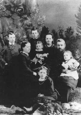
Then Standen family (left to rig): John, Andrew, Mary Elizabeth (May Beth), William John, Annie (on William's knee); Mary Ronald (left, seated); Ruth (holding doll); Frances (seated in front)
Brighton photographic fonds
Brighton photographic fonds
Class book: Queen Mary School, Peterborough, list of students and grades
Class book: Queen Mary School, Peterborough, list of students and grades
Fee book: Park Street School, Peterborough, list of students and fees
Fee book: Park Street School, Peterborough, list of students and fees
Ledger (unidentified): blacksmith; addresses indicate customers from Cavan, Otonabee, Douro and other locales around Peterborough, Ontario
Ledger (unidentified): blacksmith; addresses indicate customers from Cavan, Otonabee, Douro and other locales around Peterborough, Ontario
Index book, unidentified
Index book, unidentified
Index book, unidentified
Index book, unidentified
Ledger (unidentified): haberdasher, location unknown
Ledger (unidentified): haberdasher, location unknown
Notebook (unidentified): arithmetic exercises
Notebook (unidentified): arithmetic exercises
Index book, unidentified
Index book, unidentified
Index book, unidentified
Index book, unidentified
Index book, unidentified
Index book, unidentified
Ledger (unidentified): general merchandise; customers include Asa Burnham, Dr. George Reid, Hon. George Boulton, and others residing in and around Gore's Landing. Entry on page 411 indicates there may be a branch store in Hastings, Ontario
Ledger (unidentified): general merchandise; customers include Asa Burnham, Dr. George Reid, Hon. George Boulton, and others residing in and around Gore's Landing. Entry on page 411 indicates there may be a branch store in Hastings, Ontario
Ledger (unidentified): dry goods, hardware; customers include "Pride of Blairton Lodge No. 115", George Castle (tavern keeper, Baysfield), Cobourg, Peterborough Railway and Mining Company
Ledger (unidentified): dry goods, hardware; customers include "Pride of Blairton Lodge No. 115", George Castle (tavern keeper, Baysfield), Cobourg, Peterborough Railway and Mining Company
Ledger (unidentified): haberdasher
Ledger (unidentified): haberdasher